A visual of all tanks is available in SKY Energy. Enter a City or Zip Code in the Select a Location window and select Set Default Location to load map data.

This is the default location the map loads to when opening the Map tab, but can be changed by selecting the Filters button. Additionally, filter the view based on Delivery Types and select Apply Filters to see the results on the map.

In the bottom right corner are Map Camera Controls and a link to view Keyboard Shortcuts for navigating the map by mouse or keyboard.
Note: Current markers stay and new are added when moving around the map and when zooming in or out.


Optionally check Labels under Satellite to show imagery with street names on the map and Terrain under Map to incorporate a representation of the Earth's surface elevation, creating a more realistic and detailed view.
 |
 |
|
Select a Tank icon on the Energy Map to see a more detailed card with the tank Serial Number, Delivery/Tank type, and Customer Name. Select the detail card to redirect to the Tank Information page in a new browser tab.

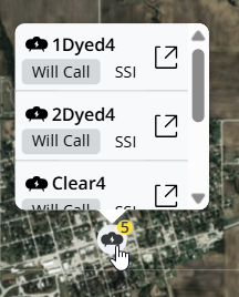
- If multiple tanks exist at the same address, the tanks will show with a stack indicator showing how many have the same location. Expand the information panel to show details for each tank at the location.
- If multiple tanks exist at a location, the tank icon will have a number indicating how many are at that location. Click the icon and scroll to view the additional tanks on the list.


